The coming and going of water in the Rovaniemi area
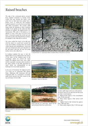
The area of the city of Rovaniemi was completely underwater after the ice age, a little more than 10,000 years ago. The glacial melt waters formed the wide Ancylusjärvi Lake bordered by the glacier, the highest beach of which was at an altitude of 215-219m. With isostatic uplift, the water level, however, began to fall rapidly, and the summit of Ounasvaara Hill appeared out of the water about 10,000 years ago. At first, the fall in the water level was fast, and as early as 1,000 years later (about 9,000 years ago), large parts of the hills of Ounasvaara and Korkalovaara were dry land. It would still have been possible to take a boat from the city centre about 7,700 years ago. Admittedly by this time, the water would already have become the brackish water of the Litorina Sea. The present Kemijoki River did not begin to flow through the city until about 7100 BC, at first descending into Kolpeneenjärvi Lake, and, after about 7000 BC, as a river all the way to Valajaskoski.
To continue to read download: ![]()